We were in New Zealand for the 36th America’s Cup. My husband, James, was the coach for
the American team. They literally crashed out of the Cup, with a near boat sinking, an all-night rescue and an unbelievable rebuild to get the team sailing again in the semi finals. After all that work, emotion and the highs and lows of competition, we all needed time to decompress. James and I headed out for some much needed New Zealand water adventure of a different sort.
Where to go? New Zealand is an embarrassment of riches when it comes to outdoor sport-oriented travel and exploration. The two of us have been to the South Island before; the last time we were in NZ was in 2003 for the America's Cup. Our travels then consisted of three frantic weeks of seeing everything, visiting one or two places for a day and quickly moving on. It is good for reconnaissance but exhausting. No need to repeat all that. Also, last time, we had young knees fine for hiking. Now, I am saving my knees for the moguls. Lastly, we like to aim for remote places and did not want to be beholden to outfitters to rent bikes, boards or boats.
Our solution? Inflatable standup paddleboards! We brought ours with us from the U.S. and the plan was to send everything else home in a container so we could travel with two bags and a backpack each. Our goal was to visit places in a way that allowed us to really explore them. To that end, we divided our four weeks into visiting three separate regions with one bonus stop. First, an expedition based from a 60’ sailing research vessel in the Dusky Sound part of Fiordland National Park. Next, a week on Stewart Island south of the southern most point of NZ, finally ten days on the lakes of the Queenstown/Wanaka area and one short bonus trip to Milford Sound.
It was hard for me to pack up the wing foiling equipment with a few weeks left in Auckland (the early autumn winging conditions were so good)! But say goodbye I did, and all but those few bags of gear headed back to Vermont. Our flight south to Queenstown was at the end of March, so we started our SUP explorations in Auckland as practice for the colder, rougher conditions of the South Island. This included time spent with me practicing paddling tucked in behind James to get towed along by his wake. We draft on our bikes to equalize our speeds, why not on paddleboards, too?
Just two days after the container went and with ten to go, James’ new inflatable paddleboard blew up. The sound more than startled the ladies sunning themselves next to where we were setting up. While we were happy it didn’t happen at sea or on the South Island, we had to scramble to find a replacement. James is a big dude: 6’1” and around 240. Not any old 12’6” off the rack would work, especially for where we were going in cold, rough water and potentially far from other people.
Despite the pandemic’s universal lack of supply with sports equipment, we found the last two Red Voyager 13’ 2” SUPs in the country of New Zealand. We demoed one for James, realized it was a far better tool for the expedition than the raceboard I was using, and pulled the trigger on both. Matching boards for us is not my normal jam, but when it’s the right piece of equipment, that’s what you do. We secured storage on a last minute container back to the States for my raceboard and James’ blown up one (can you recycle PVC?) and were now set to travel. The Red bags with PFDs and wetsuits, boards, paddles, pumps and repair kits came in .25 of a kilo under max weight for the airline. Perfect. Putting a tough professional experience behind us, our great adventure began.
Dusky Sound: Weathery and Remote
At 5AM, we left our little motel room in quiet Te Anau, drove down a long dead-end road to Manapouri, the westernmost town in New Zealand on the eastern shores of Lake Manapouri. We then traveled by ferry to the western side of the lake and home to the Manapouri Hydro Station (not accessible by cars - unless they came by landing craft). From there, we drove over a high mountain pass to a boat at the head of Patea/Doubtful Sound.
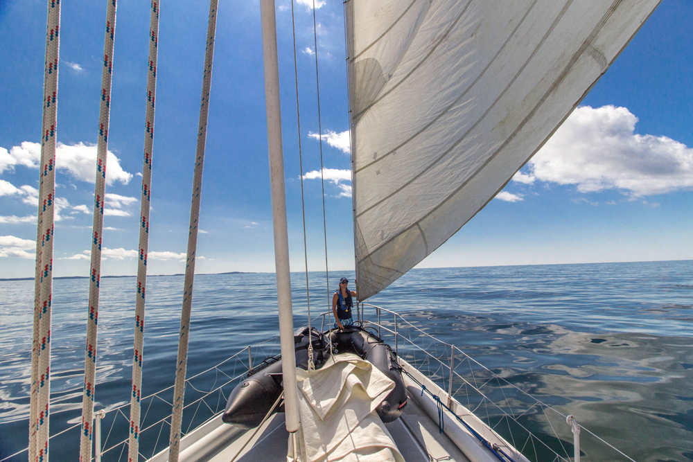
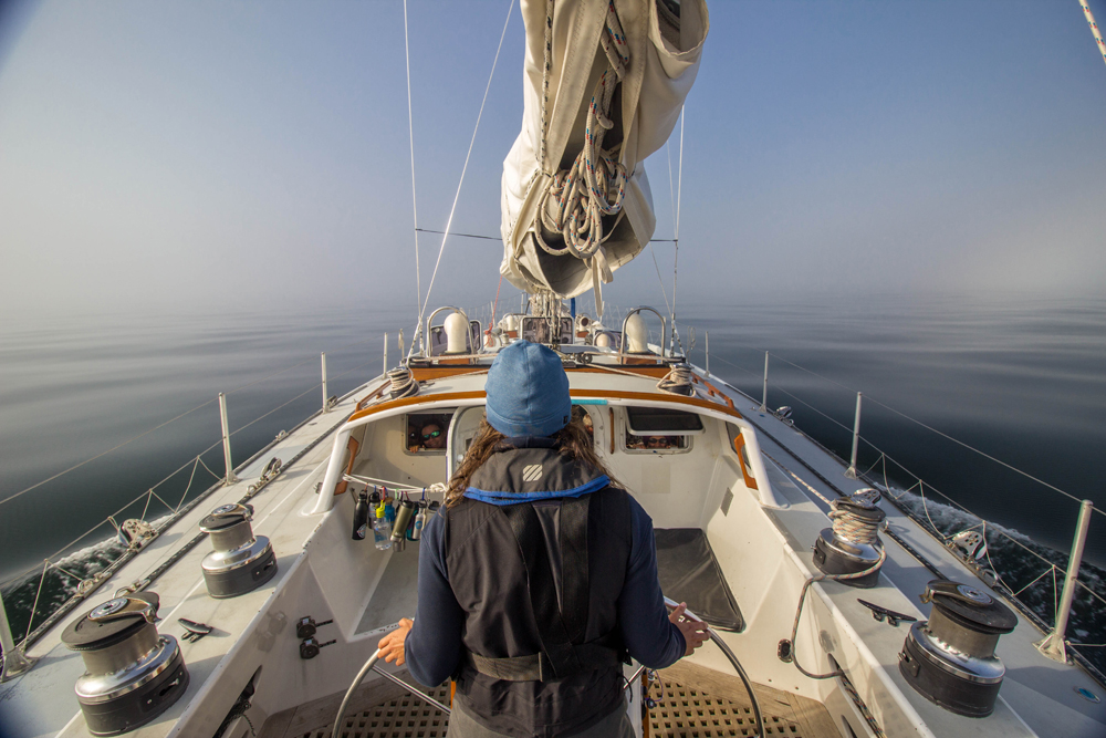
The boat was the Breaksea Girl, a 60’ sailing research and expedition vessel temporarily docked and bound for Supper Cove in Tamatea/Dusky Sound by way of the myriad nooks and crannies of the Te Puaitaha/Breaksea and Dusky Sounds. These are the more remote parts of the already remote Te Wāhipounamu/Fiordland National Park, a UNESCO World Heritage Site.
Our goals while on board the vessel were to sail, SUP, freedive and explore. We were met by the crew of the Breaksea Girl. Brian, along with his partner Fi, own Wild Fiorland and this incredible fit-for-purpose boat. Brian is a quiet, competent and knowledgeable captain with a reputation for being able to fix anything, anywhere. Scotty, our first mate, was full of enthusiasm and energy to share his vast knowledge about the ecosystem and indigenous people. Finally, Kim, the chillest of boat chefs who, without drama, kept us supplied with warm muffins in the morning and hearty meals throughout the day while telling stories of living on nearby islands to conserve threatened land birds native to the region. The only others on board were a young photographer and his girlfriend. Oscar and Tessa were great company and fun sailing and free diving companions. We were seven on a boat rated for 17. Perfect.
Our ultimate area for exploration was Dusky Sound in the southwest section of Fiordland National Park. It is one of the rainiest places on earth, virtually inaccessible by anything other than boats (but not little ones), feet (but only very fit and hearty ones) and helicopter (and then, only on the tops of mountains or the occasional rock that sticks out into a fiord).
The first objective was to get out of Doubtful Sound, down the coast, and into the protection of the Breaksea/Dusky Sound area before a big weather system coming in from the Southern Ocean shut the door on us. Our bags were still on deck when Brian and Scotty cast off the dock lines and we started steaming due west heading for the Tasman Sea. The expedition started with a family of dolphins - two adults and a baby - surfing our bow wave. I always see dolphins as a good omen and having this happen one hour into the trip was a great lead-in to an incredible four days.
Despite the fact that I am a lifelong sailor (competitive more than recreational) and a captain of a similar 60’ sailing research vessel (American Promise, check it out), there is one combo of sea state and boat angle that has the power to render me useless. That is exactly what we had just after we turned south outside of Doubtful Sound. Swells that started in the Antarctic were in charge of the boat and we rolled as much as steamed south along the rugged, rocky and virtually inaccessible coast.
Luckily, I know this about myself and expected the motion, so I committed to a bench in front of the pilot house facing the bow and tucked in under a tartan boat blanket with my camera, binoculars and pockets full of Sour Patch Kids. Did you know that a well-timed handful of Sour Patch Kids can help prevent or reduce seasickness?*
*Note: This info comes from a very informal study done by me on American Promise over the last nine years of marine debris research, cleanup and education expeditions in the U.S. between Manhattan and Maine.
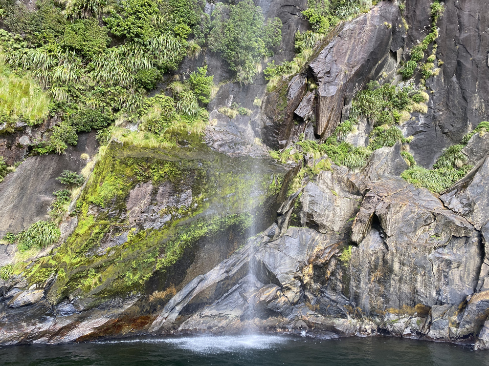
What didn’t take me nine years to learn was that watching an albatross is also an excellent way to forget about feeling the roll of the boat. Before this day, I was a self-proclaimed “not a bird person”. Not anymore. I am now an all-in fan of albatross, in particular a species called the Buller's albatross or Buller’s mollymawk. These gliders are endemic to New Zealand and distracted me from any potential misery for five hours until there was a break in the jagged rocks and we were welcomed into Breaksea Sound. For the next four days, we witnessed some of the most spectacular scenery on the planet, learned about the natural and human history of the area, went free diving with playful NZ fur seals, saw black coral up close in all of its snow-white glory and so many waterfalls that I stopped counting. The expedition was full of incredible moments. Here are just a few that stood out.
On a night of 70 knots at the very top of Wet Jacket Arm, the wind was from the very same system that we had hustled to get ahead of. The area in which we spent that first night is a great example of how the indigenous Maori people named the places with respect to the place and its natural creatures, shapes or resemblances, and how Captain Cook and his men used a very British method of naming everything after their own experiences. Yes, someone on Captain Cook’s crew did get their jacket wet where we spent that first night. There is Anchor Island (where Cook anchored) named Pukenui (big hill) by the Maori, Resolution Island (named after Cook’s ship) called Tau Moana (come to rest at sea) by the Maori people. There is also Maori Point (Cook met a Maori family) and Astronomy Point (where they set up a telescope), you get the point. This location could have been named by anyone as Good Place to Hide from 70 Knots Arm, because that was exactly what it was. Seventy knots of wind is a lot and though the boat did need an all-night watch (thank you Brian and Scotty), we stayed put despite the gale.
We did some walking on the islands and heaps of sitting on that bench in front of the pilot house or leaning against the rail just ogling the scenery. James and I are water people. Unsurprisingly, it was the chances we had to really connect closer with the fiord that stood out. These came in the form of standup paddleboarding for James and freediving for me.
James’ most intimate SUP experience happened in the bay adjacent to Pigeon Island when he glided up to a waterfall and was able to paddle between the water and rock. At the same time, perhaps due to the freshwater, he found himself surrounded by hundreds of round, globe-like jellyfish - like paddling around a barrel full of apples or a mug of hot chocolate with floating marshmallows. He was all alone, so there are no photos, but I think his being alone in such a far away part of the world, with only our boat unseen around the corner, intensified the moment for him.
My own breathtaking experience came from underwater rather than above it. We went free diving every day. Despite the fact the water was in the 50’s, the boat sported the right gear to give us comfortable access: 5mm open cell freediving wetsuits and a heap of dive weights. Our second dive was along the rocks of Luncheon Cove. James was off on the paddleboard getting eyeballed by curious seal pups while we got to swim with them. Playful and inquisitive, it was clear we were in their territory. There were dozens of NZ fur seals around, but it was the smaller ones who had the seal version of the zoomies. They are as graceful as they are fast and would come in and out of range of our group, emerging out of the turquoise to play an underwater version of chicken with us, only to dive below at the last minute. I think one nibbled on Kim’s three fingered-dive gloves.
The final day, we loaded our SUP bags and one small bag each into the helicopter that would fly us over the mountains back to Te Anau and our car, buildings and other people. We had full hearts, full SD cards and were feeling inspired in a way unique to water expeditions that are all about the ocean, the land, its creatures and the opportunity to connect with them all.
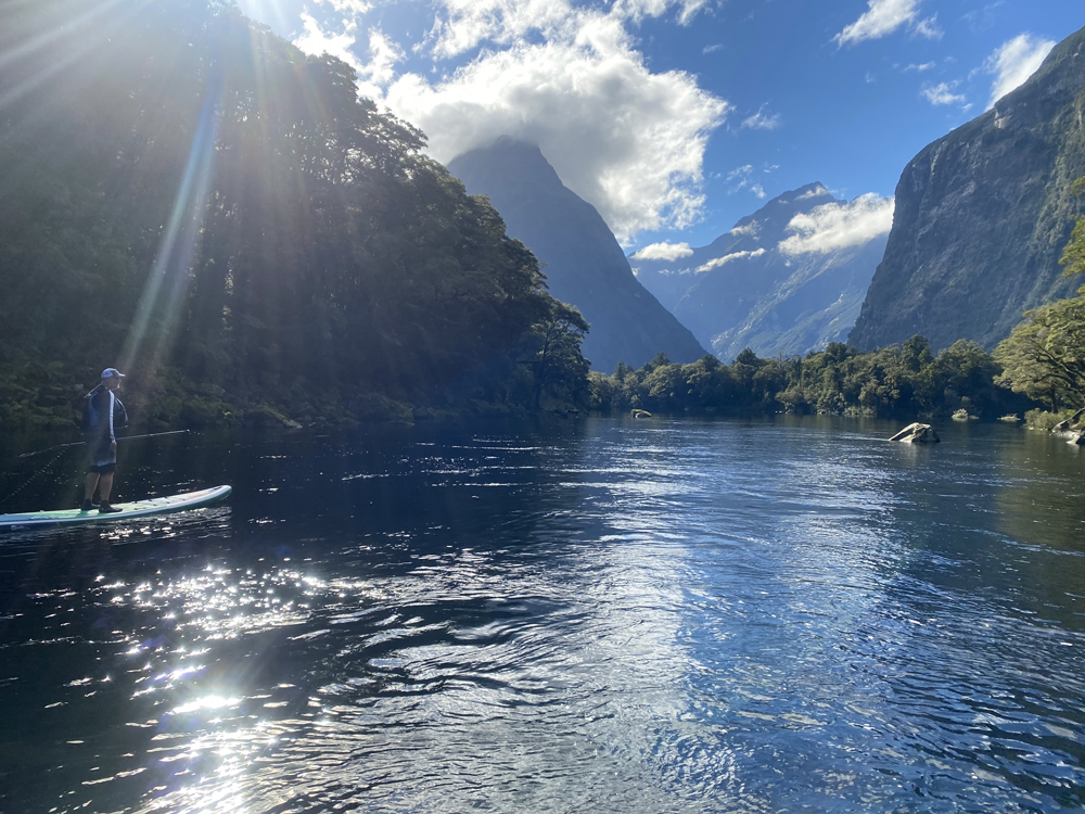
Milford Sound: Where the Sun, Stars and Mitre Peak align
Immediately after the helicopter landed, we were deposited back into civilization full of roads, cars and lots of other people. This is always a shock after an experience like the one we had on the Breaksea Girl. We reunited with our Skoda rental and headed, somewhat mundanely, by road to Piopiotahi/Milford Sound.
Milford Sound, at least logistically and structurally, reminded us of a Yosemite-like challenge for the New Zealand government that was met with a Yosemite-like solution. If one is not willing to get in a tiny plane or helicopter, Milford Sound is accessible by only one road. One windy, steep, switch-back road that is stunning, definitely dangerous (it is frequently closed in the winter due to icy conditions and avalanches) and one my mother would hate. It climbs to a height of 3,100’ (945m), shunts through the impressive one-lane Homer Tunnel and ends with an ear-popping drop down to sea-level. Similar to Yosemite, the flat parts of land are not vast, making for a natural regulator and limiting infrastructure like buildings, hotels and parking lots. There are just two options for accommodations within approximately a 2 hour drive. There is a government imposed, yet hard-to-enforce limit of 4,000 thousand visitors to Milford Sound every day (exceeding 1,000,000 per year).
Before you get to the Sound itself, there are signs stating a lot of rules. Most of them prohibit you from parking anywhere until you get to the central parking area. Just like Yosemite.
Honestly, driving in we were nervous. Getting corralled with a lot of people is not our thing.
Remember, we had just gotten off a boat in the most remote part of this country; getting tossed in with heaps of other people doing land things can be jarring after such an experience. We were happy to ease back into it. Furthermore, while this is not a story about COVID, it is taking place during the pandemic, and though there were no community cases in New Zealand at the time, they had just opened the trans-Tasman bubble. This meant Australians could travel to New Zealand without quarantining, but Australia kept having outbreaks. Being right in the middle of one of the Aussies’ most popular destinations in NZ, we were even less excited to mix with anyone.
That evening, we decided we would launch our SUPs off the public ramp in Milford’s smaller harbor the next morning. It was unclear if that was allowed or if we were allowed to even park there. Our backup plan was to suck it up and take the tourist boat cruise to the end of the fiord and back in the afternoon. We were required to use public ramps in this part of the country, so I went online and registered our boards as part of a Clean Vessel Pass program to help stop the spread of invasive species.
We knew our SUP window was relatively small. As sailors, we are always hoping for wind. As paddlers, we are hoping there won’t be any wind. That is a big ask in this part of the world. Here it feels weathery and it is weathery. The forecast gave us until around noon before a westerly was going to roar straight up the fiord and make paddling impossible. I have around a 12-15 knot threshold where stand up paddling goes from bliss to what can only be called a love/hate mission. For that reason, we are careful about where and when we launch and respect the forecasting as well as our own experience and powers of observation. Luckily, James is one of the best at looking around and deciding when we need to be racing back to the place from which we launched.
We smashed our world record for pumping up the boards and getting onto the water FAST thanks to the 80 million sandflies eating us for breakfast. Launching for me requires just a few minutes of busy work: putting on the leash, starting my Wahoo/Strava app, making sure the dry bag with the keys is closed. It is all heads down and futzy. Then, when I stand up, I get to take in wherever I am and the moment. Milford Sound is one paddle that remains crystal clear in my mind for the 360 degree views of breathtaking mountains, waterfalls and sunlight.
When we launched, the wind was still light on the water, but the clouds were on the move, sliding up and down the mountainsides, snaking up into the valleys toward glaciers and assembling above the highest peaks. I could see a handful of glaciers, twice as many waterfalls and more mountains than were countable. One waterfall was like a magnet and that is where we headed. We learned later it is called Bowen Falls and it is rare to access it from the water from anything but one of the big tour boats. Another reason why we appreciated using paddleboards as our adventure medium is because they are water based and shallow enough to get in close to places other boats (or people without boats) simply can’t.
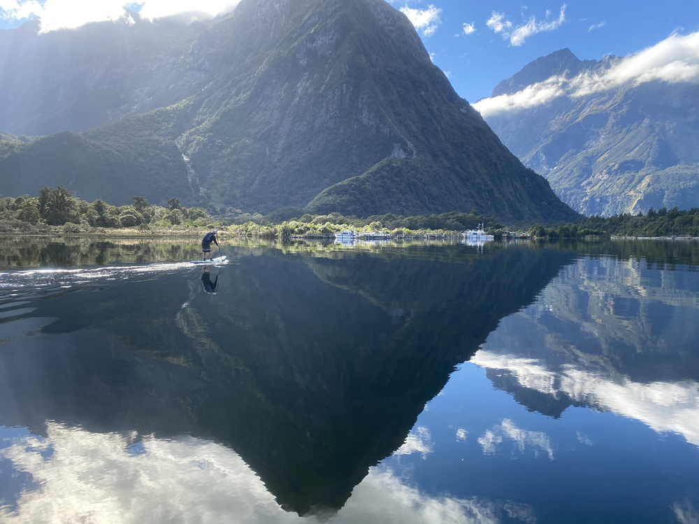
Paddling back to the car to stay ahead of the incoming wind gave us fresh views. Every angle was stunning and different. As someone who grew up in the mountains and on mountain lakes, I have to say that I was surprised by the amount of current. I should have known, this fiord is not far from the Tasman Sea (only 9.9 miles), and while the scenery didn’t make it feel like an open water paddle, that is exactly what it was in terms of the strong current and changeable conditions. We overcame the SUP treadmill and made it back, luckily before the wind picked up and were grateful for the experience and the fact that our car was still there. We were feeling so good and happy that we kept our Plan B and took the boat tour. Glad we did. Due to COVID, there were only a few visitors and rather than being sardines on the boat, we staked out our own area on a high deck facing forward, put on a heap of layers for the freshening breeze coming from the ocean, and enjoyed seeing the whole of Milford Sound in luxury.
The next day we had a ferry to catch at 5pm. Google said it would take four hours to get from Milford Sound to Bluff. There was absolutely no wind for the morning forecast. We couldn’t resist and calculated that if we were off the water and in the car by eleven o’clock, we’d make the ferry and get in a bonus paddle on Milford Sound. So we did. It was magic. The morning light in the mountains comes later than on a flat coast so we were treated to what felt like a sunrise. The wind was nowhere to be found and the surface still enough to reflect every tree, bit of moss and cloud and color in the sky. We paddled up an arm we had skipped the day before in favor of the wide part of the fiord and found the terminus of the famed Milford Track. The wind stayed absent for the whole paddle and it was hard to stick to our can’t-push-it end time. But we did and were driving east and gaining altitude toward the tunnel pass right at 11AM.
South of the South Island: Next Stop, Antarctica
A funny thing about remote places with unreliable internet and little or no cell service is that weird digital things happen. Like, when getting directions, one’s phone can use one’s previous location as a starting point rather than one’s current position. And it tells you a trip will take 1 hour less than it really does. Our stunner of a morning paddle in Milford Sound was worth every second. But thanks to a glitch in the system, our no-rush drive to the bottom of the country turned into a full-on test of James’ Skoda handling skills as we worked to safely (and legally) make up an hour on our Google directions.
First the mountains of Fiordland, then the agricultural plains of lower Central Otago and finally villages of Southland sped by in a blur until we made Bluff with time to spare. After loading our paddleboards and bags into metal bins that would be transferred to the ferry, we even had enough time to seek the top of the highest hill and look south toward the southernmost tip one can live on in New Zealand without being on the Antarctic continent: Rakiura/Stewart Island. In Maori language, Rakiura means “land of the glowing skies”. This was our destination and expedition base for the next week.
Stewart Island is the third largest of NZ’s islands and 85% of it is a national park. It is a night-sky sanctuary and crisscrossed by walking tracks including the famed Rakiura Track. Population: 408 (as of 2018). Very few Kiwis whom I met over the last ten months have even been there. Its land is home to several species of land birds including free-roaming and elusive kiwis (birds, not people). Its waters feature penguins, sea birds (including my new favorite albatross), marine mammals of all sizes and even great white sharks.
April in New Zealand is the autumn season and the shortened daylight meant that our 5PM ferry ride included sunset. Spray flying, we hammered due south from Bluff, watching the sun set and the mollymawks surf our air wake. Accommodations are limited in Stewart Island and it seems like AirBnB has the biggest options. We scored a place with both views and a car and someone to pick us up at the ferry. We were grateful they did not freak out by the two large SUP bags plus everything else. In our regular life, James and I live in a small town in the mountains of Vermont so we are familiar with this kind of life, including shops that close earlier than in the cities. As a result of our timing snafu, we didn’t have time to pick up groceries on the mainland and only had a few granola bars to add to the ketchup and soy sauce left in the house by the people before us. Since that was not the dinner we had in mind, we hustled to make it to the shop by its closing time of 7PM and I ran in, somewhat out of breath, at 6:51.
First interaction with a local. The shop merchant sensed my quasi panic over time and said to take my time, no rush. Thank goodness it was that kind of island! The kind with island time and friendly locals laughing at the rushed people from other places. I managed to pick up veggies for dinner and items for the next day’s breakfast and lunch just as 7PM rolled around. While checking out, I was still thanking the merchant for not kicking me out and letting us starve that night. He said, and I quote, “You could have always eaten your fingernails.” Hmmm. I have to admit, I spent time while paddling the next day pondering that one and it became a central point of our conversation when I went into the shop every day thereafter. Is that a thing? Do the locals here know something the rest of us don’t? What about the foliage, would that not be better? What did this guy do before living here?
When James and I had planned our Stewart Island trip, we had in mind a combination of paddling from shore and hiring water taxis to drop us off in various bays to paddle farther afield and as south as possible. Our reality, though, was that the water taxis were prohibitively expensive and the weather that week (and most weeks) was somewhat extreme, especially farther south. We decided there were more than enough places from which to launch ourselves.
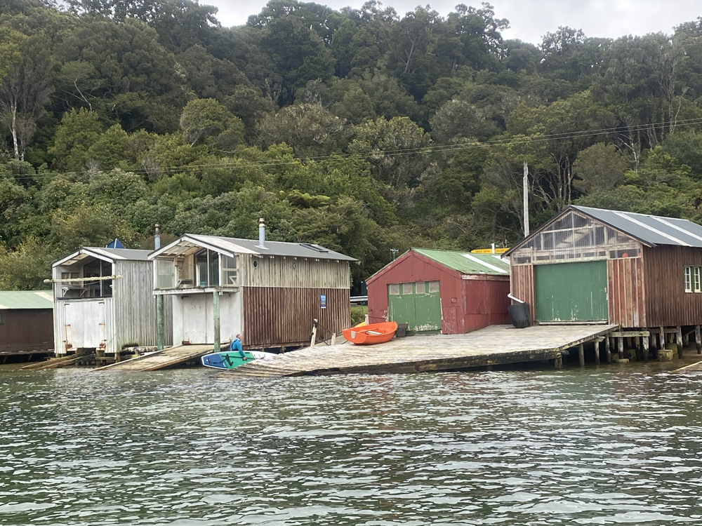
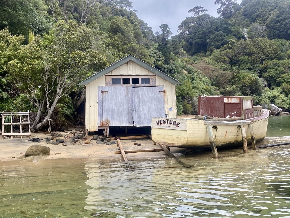
Every day we paddled and explored different coves from different parts of the Stewart Island coast. We explored shipwrecked fishing boats and quaint boat houses (a watercolor painter’s dream). We paddled south, bows toward the Southern Ocean, and we soaked in every albatross sighting. There is something about those birds that sings to me. Maybe something a touch familiar; graceful in flight but somewhat of a tumbling mess at the margins in takeoff and landing. James might have paid me the highest athletic compliment I have ever received after watching some of the Buller’s mollymawks cruising with the air currents off the Ackers Point lighthouse. He said I wing foil like an albatross - smooth, even, and kind of chill. I am not sure if he also meant that my take offs and landings are somewhat fraught, but if he did, he’d be right. I can live with that.
In addition to our time swimming with seals in Dusky Sound, our paddles off Stewart Island featured a variety of sea creatures and our closest natural encounters from our trip. One day we were paddling along a rock island (just one, huge rock), with James ahead as he often is, when he sat down on his board for a drink while I caught up. Just as I neared, an albatross tumbled out of the sky. Seems like it didn’t notice that James was right on its runway and the albatross landed with around three feet between them. The two looked at each other with the same surprised expression. Then they both looked back at me with twin looks that just dared me to comment. The magical bird didn’t stay for long, leaving us satisfied but wanting more. Around ten minutes later, James saw a splash up ahead and just as he said he thought he saw something, a glint of light and motion caught my attention. Suddenly, I was looking right into the eyes of a leopard seal cruising right under my paddleboard! The seal went and got an eyeful of James behind me and took off. Some research later on the internet when we got back to our housing made the ID (a fun activity in itself). Leopard seals can be a little frisky and enormous. We were happy to have had such a serene connection with one.
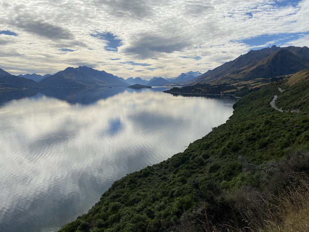
Lake Whakatipu: Lake in the Middle of Middle Earth
Picture a mountain lake. Now intensify everything about it. Make the water crystal clear. Give it more blue with brilliant turquoise around the edges. Imagine the mountains even taller, their peaks sharper. Color the sky even more blue. And take away the people, take away the jet skis, take away drunken boat parties. What you are left with is Lake Whakatipu. This L-shaped, glacier-made mountain lake sits at the confluence of Aspiring and Fiordland National parks. Four lift-served ski areas are all within a 45 minute drive and it is fed by two stunning rivers, the canyon-dwelling Shotover and wide, braided Dart River. Many of the most dramatic landscape scenes in the Lord of the Rings Trilogy were filmed in this region. And no wonder. It is breathtaking in every direction.
The outdoor sporting activities on Lake Whakatipu are many: skiing, mountain biking and tramping (hiking if you are not a Kiwi) are a few of the biggest. Other main attractions include jet boat rides on the Shotover and Dart Rivers, a gondola ride to get you high above Queenstown, and flying in various aircraft to access the glaciers and high peaks of the Southern Alps. For the more winddriven, paragliding, kiting, winging and windsurfing are all available for those with a tolerance for great height, cold water and a potential gusty breeze. Despite the color of the water, the tropics it is not.
It felt like we had the whole lake to ourselves. Perhaps this was because it was autumn with a chill in the air, or the water was too cold, or perhaps people were too busy mountain biking. We were the only stand up paddle boarders on the lake that day and every day and had views of stunning scenery and each other. Just how we like it.
As a sailor and sea/river based expedition scientist, the vast majority of the explorations I have done have been from the deck of a boat, usually a sailboat. Not necessarily one moving that fast, but certainly faster than I can propel a paddleboard. For that reason, we found exploring by SUP an opportunity to witness more, to take in the sounds more deeply and to connect more fully with the water, its sea life and the landscape around us. This was an opportunity to enjoy the sunlight and detect subtle wind shifts by how much pine tree scent blew across our boards. Being on a paddleboard and launching from the same place for multiple days allowed us to do more than just see a place and move on, we came to know it.
This New Zealand water expedition delivered everything we were hoping for: the remoteness of natural landscapes, intimate access to a coast rarely traveled and even less often slowly traveled, as well as affording us up close and personal experiences with sea life, both birds and marine mammals. It was an athletic adventure, a mix of salt water fed by the Southern Ocean and fresh water from mountain top glaciers and it provided us some distance from the intense professional disappointment we had experienced at the 2021 America’s Cup. James and I agreed we would both go back in heartbeat, but I think we might see this trip as inspiration for further SUP exploration in other high latitudes. It’s great food for thought as I paddle across the lakes and ponds of Vermont.